
Magnitude 7.7 earthquake strikes Panama; USGS reviews the data
USGS records an earthquake on October 9 at 17:56:06 GMT, 12 km west-southwest of Pitaloza Arriba. Parameters remain subject to revision.
RockGeo Editorial · Published on
Event date: 10/09/2026, 17:56 GMT · Source date: 10/10/2026, 14:53 GMT
Sources accessed on 10/10/2026, 15:02 GMT
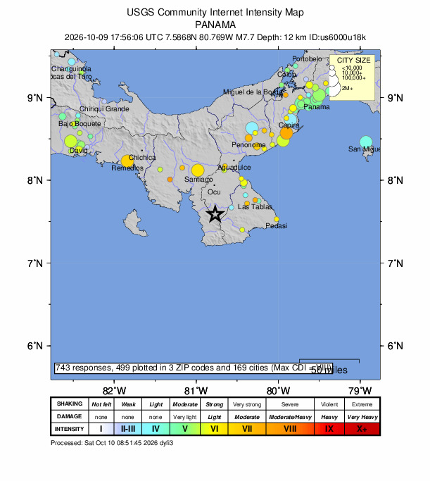
U.S. Geological Survey / Did You Feel It? · Public Domain (USGS)
The United States Geological Survey catalog records a magnitude 7.7 earthquake in Panama on October 9, 2026, at 17:56:06 GMT. Event us6000u18k was located 12 km west-southwest of Pitaloza Arriba. This article presents the parameters checked on October 10 while preserving the earthquake’s actual date.
The consulted solution places the epicenter at 7.5868° north latitude and 80.769° west longitude, with a depth of 12.647 km, approximately 12.6 km. The epicenter indicates the surface position; depth describes the focus below it. These numbers alone do not outline the entire rupture area.
The catalog lists the magnitude type as mww, a moment-magnitude determination. USGS documentation explains that this measure relates to the physical properties of rupture, including rock rigidity, the area that slipped and displacement. It describes the size of the earthquake rather than a count of damage.
Shaking intensity varies between locations. Distance from the rupture, propagation direction and surface geology can modify the local response. A single magnitude therefore does not mean equal intensity in every city. The Did You Feel It? map collects reports of perceived shaking and should be read as that kind of observation.
The record was marked reviewed when checked. This means the solution received review without making its parameters immutable. Seismic data remain preliminary for monitoring purposes and may change with further analysis. The event time should not be confused with this news article’s publication time.
We do not present loss estimates as confirmed casualties or damage, or infer tsunami warnings from magnitude. The official link allows readers to follow revisions to the same event. For geoscientific interpretation, location, depth, magnitude and intensity provide complementary information with different roles in understanding the phenomenon.