
Arnab: satellite captures cyclone before India landfall
A nighttime image from 26 October, released by NASA on 29 October, shows Arnab over the Bay of Bengal. IMD confirms the coastal crossing on 28 October.
RockGeo Editorial · Published on
Event date: 10/26/2026, 20:12 GMT · Source date: 10/29/2026, 04:01 GMT
Sources accessed on 10/29/2026, 20:01 GMT
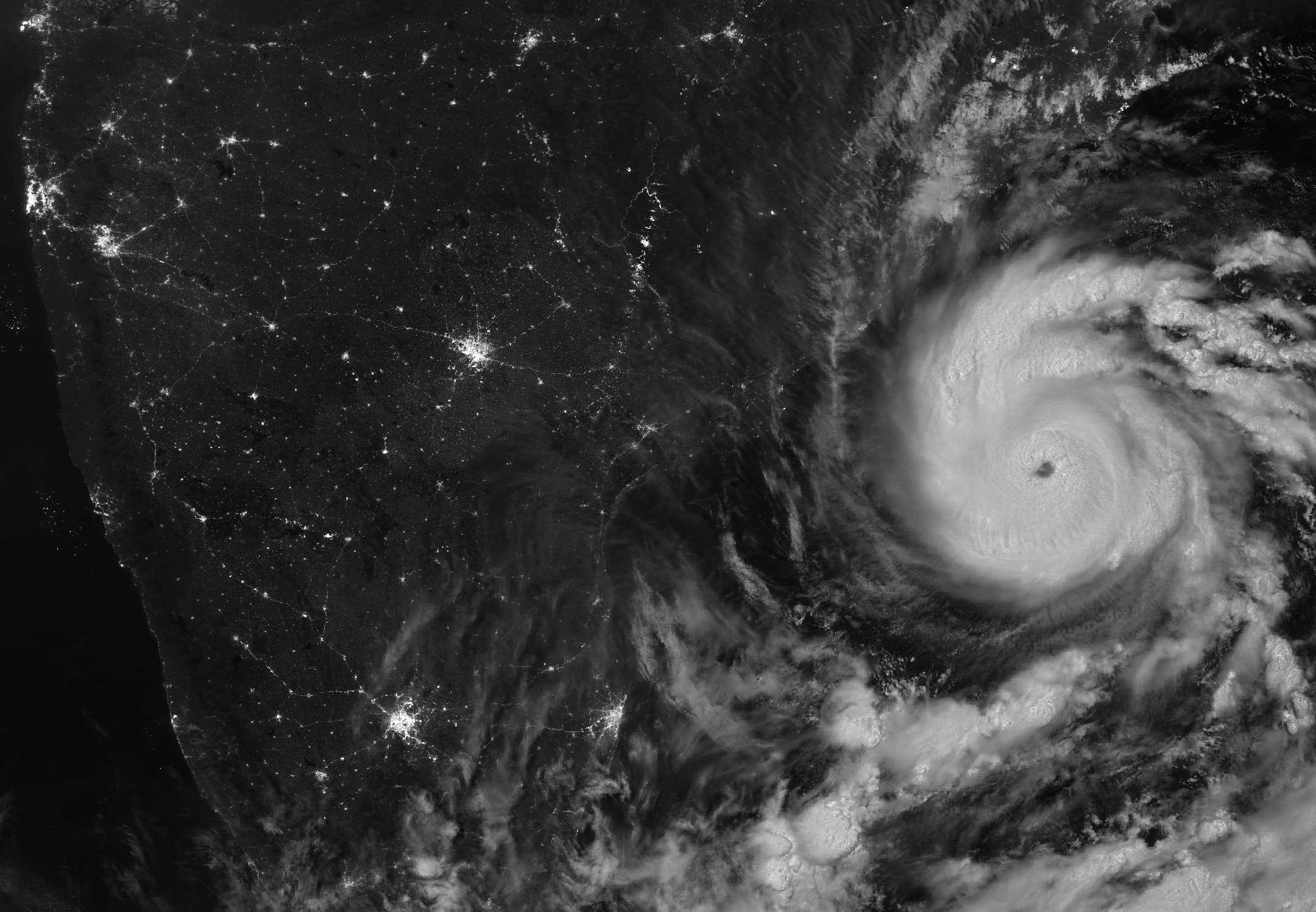
NASA Earth Observatory / Michala Garrison; NOAA-20 / VIIRS · NASA Media Usage Guidelines — informational/editorial use
A nighttime image released by NASA Earth Observatory on 29 October 2026 shows Cyclone Arnab over the Bay of Bengal before it reached India’s east coast. NOAA-20’s VIIRS sensor captured the scene on 26 October at 20:12 GMT (UTC+00:00). Adam Voiland’s account places the observation before arrival in Andhra Pradesh and Yanam.
India Meteorological Department (IMD) national bulletin 25, issued on 28 October at 06:30 GMT, confirms the crossing between Bapatla and Visakhapatnam, southwest of Yanam. The reported interval corresponds to 27 October at 20:30 through 28 October at 02:30 GMT. Maximum sustained winds were 125–135 km/h, gusting to 150 km/h; IMD classified it as a very severe cyclonic storm.
The image uses VIIRS day-night band data. Bright clouds define the circular structure and eye, while city lights appear on the dark continental portion. NOAA describes VIIRS as an instrument observing visible and infrared bands, with products covering clouds, aerosols, oceans and other environmental components. Nighttime observations complement meteorological monitoring but do not replace an intensity bulletin.
For coastal geoscience interpretation, the bulletin distinguishes wind, sea conditions and storm surge. It forecast 3–6 m swells along northern Andhra Pradesh and southern Odisha, and a rise of about 1 m above astronomical tide in low-lying Andhra Pradesh areas. These are historical forecasts from that document; they do not demonstrate measured heights or inundation extent.
Image acquisition, publication and coastal arrival mark different stages. The isolated orbital scene cannot measure the cited winds or count ground damage; those wind figures come from IMD. The entire file has been preserved. This report presents neither the 26 October image as real-time conditions nor coastal forecasts as confirmed observations.